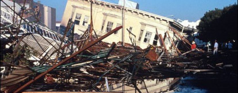
Is Your Home Earthquake Proof? (Part I)

I am afraid that under the current circumstances it may not be ethically correct to ask that question right now, but I am sure that more than one reader had wondered about the stability of their homes before an earthquake specially as we are on earthquake zone.
Although it is a highly technical matter, I believe that we can converse about the subject circumscribing to general information, so that at the end of the following expositions some of us (including me, I had to carry out some research on the subject and dust up the old text books) would understand a little better how our buildings literally stand up, should an earthquake occur around East Spain.
The zones most likely to occur earthquakes in Spain are in Granada, Murcia and Alicante.
In recent years in Spain, earthquakes with magnitudes greater than 4 degrees (Richter scale) have taken place causing considerable damage to buildings. For example, the earthquakes in Andalusia on Dec. 23rd , 1993 and January 4th, 1994 with a intensity in both cases of 5.0 degrees and with epicentres in the province of Almería, near the towns of San Roque and Berja, and 20 km from the coast off Almerimar Balerma and Bath respectively (Yépez, 1994). In Galicia on May 22nd, 1997 with intensity 5.1 and centred near the towns of Sarria and Becerreá and the latest occurred in Murcia on February 2nd, 1999, of intensity 5.0 and centred about 5 km north of Mula (Mena, in1999).
There are historical records of great seismic activity in south Europe in countries such as Turkey, Greece, Yugoslavia, Italy, Portugal, and of course Spain.
Devastating earthquakes, as was the one on 1st of November 1755 on the southwest of the Iberian Peninsula, producing high waves and its destructive power caused between 50,000 and 70,000 deaths. In Lisbon and surroundings areas on December the 25th of 1884, an earthquake killed 800 people. In Alicante in the year 1500, another earthquake destroyed some 4,400 homes and damaged 13,000. In Messina Italy, 28th of December 1908 an earthquake killed 120,000 people and caused considerable damage in the infrastructure of the city.
The two seismic activities which have produced the highest numbers of deaths happened in China, one in 1556 in the province of Shaanxi, where 830.000 people died and more recently, in 1976 an earthquake of intensity 7,6 in the region of Tangshan, generated 650.000 deaths.
I haven’t found records on the economic losses which obviously are concatenated with disasters of that enormity, and most important o all, there are no way of quantifying grieve and suffering generated by the loss of loved ones. It is not a trivial issue what we have here.
But why do earthquakes occur?
Earthquakes occur when stresses accumulated due to the deformation of the earth layers are released abruptly. Broken masses of rocks sometimes large as whole mountains are subject to enormous forces and rearrange themselves releasing enormous energies that shake the earth surface with tremendous force. The (hypocenters) are located at different depths, the deepest being up to 700 kilometres. They are particularly common near the edges of tectonic plates. Believe it or not, there are about one million earthquakes recorded every year, although most of them are of such low intensity that goes unnoticed by us.
They act instantaneously over a wide area and can cause seismic waves, (tsunami) similar to the recent one in Japan that was transmitted live world wide and may also cause landslides, appearance and disappearance of springs, construction damage and deaths, mostly due to the collapsing of buildings.
They are very difficult to predict and, at present, there are no effective systems to warn people in advance of an imminent earthquake.
Intensity and magnitude of earthquakes
To describe the strength of an earthquake and resulting damage, there different scales that measure their intensity and magnitude.
We can measure its intensity, which is a subjective measure of the effects of earthquakes on the earth surface, people and man-made structures but without using any technical instruments. It is based on observing the consequences that take place during an earthquake. It is useful to explain an earthquake in areas where there are no seismographs near and enable us to compare ancient earthquakes.
The magnitude is an objective measure of the energy of an earthquake which is reflected by seismographs. The best known and used scale is the Richter scale (1935) and measures the logarithm of the maximum amplitude of a seismogram recorded by a standard instrument, at a distance of 100 kilometres from the epicentre. This method has been corrected later, but the basic idea remains the same. As the scale is logarithmic every step up involves multiplying by the ten the intensity of the lower number. i.e. Roughly speaking an earthquake grade 7 is equal to one of intensity 6 multiply by ten. There are 12 degrees in the scale from 1 to 12 being 1 so small that is only felt by technical apparatus.
An earthquake measuring 12 on the Richter scale would break the earth in two.
This concept allows classification of earthquakes:
Complete destruction M = 12
Large earthquakes M > = 7
Moderate earthquakes 5 = < M < 7
Small earthquakes 3 = < M < 5
Micro earthquakes M < 3
The EMS scale is officially used in most European countries and is utilized in the calculation of building and all types of structures by architects and engineers in Spain known as “Norma de Construcción Sismorresistente: Parte General y Edificación (Ncsr-02)” Earthquake-Resistant Norm.
Now that we have established the basic principles for measuring earthquakes, in the next issues of CBN we will examine what precautions we architect take when designing buildings in Spain.

 Spanish
 German
 Dutch
Dutch